With Gaia GPS loaded on your phone,
Click on which section you want:
California Section A — Campo to Warner Springs
GPS Track (the PCT) | GPS Waypoints (landmarks)
California Section B — Warner Springs to Highway 10 (near Cabazon)
GPS Track (the PCT) | GPS Waypoints (landmarks)
California Section C — Highway 10 to Highway 15 (Cajon Pass)
GPS Track (the PCT) | GPS Waypoints (landmarks)
California Section D — Highway 15 to Auga Dulce
GPS Track (the PCT) | GPS Waypoints (landmarks)
California Section E — Agua Dulce to Tehachapi Pass
GPS Track (the PCT) | GPS Waypoints (landmarks)
California Section F — Tehachapi Pass to Walker Pass
GPS Track (the PCT) | GPS Waypoints (landmarks)
California Section G — Walker Pass to Crabtree Meadow (near Mt Whitney)
GPS Track (the PCT) | GPS Waypoints (landmarks)
California Section H — Crabtree Meadow to Tuolumne Meadow (Yosemite)
GPS Track (the PCT) | GPS Waypoints (landmarks)
California Section I — Tuolumne Meadow to Sonora Pass
GPS Track (the PCT) | GPS Waypoints (landmarks)
California Section J — Sonora Pass to Echo Lake
GPS Track (the PCT) | GPS Waypoints (landmarks)
California Section K — Echo Lake to Highway 80 (Donner Summit)
GPS Track (the PCT) | GPS Waypoints (landmarks)
California Section L — Highway 80 to Highway 49 (near Sierra City)
GPS Track (the PCT) | GPS Waypoints (landmarks)
California Section M — Highway 49 to Belden
GPS Track (the PCT) | GPS Waypoints (landmarks)
California Section N — Belden to Burney Falls State park
GPS Track (the PCT) | GPS Waypoints (landmarks)
California Section O — Burney Falls State Park to Highway 5 (near Castle Crag)
GPS Track (the PCT) | GPS Waypoints (landmarks)
California Section P — Highway 5 to Etna Summit
GPS Track (the PCT) | GPS Waypoints (landmarks)
California Section Q — Etna Summit to Seiad Valley
GPS Track (the PCT) | GPS Waypoints (landmarks)
California Section R — Seiad Valley to Highway 5 (near Ashland, OR)
GPS Track (the PCT) | GPS Waypoints (landmarks)
Oregon Section B — Highway 5 to Highway 140 (near Fish Lake)
GPS Track (the PCT) | GPS Waypoints (landmarks)
Oregon Section C — Highway 140 to Highway 138 (near Cascade Crest)
GPS Track (the PCT) | GPS Waypoints (landmarks)
Oregon Section D — Highway 138 to Highway 58 (near Willamette Pass)
GPS Track (the PCT) | GPS Waypoints (landmarks)
Oregon Section E — Highway 58 to Highway 242 (McKenzie Pass)
GPS Track (the PCT) | GPS Waypoints (landmarks)
Oregon Section F — Highway 242 to Highway 35 (near Barlow Pass)
GPS Track (the PCT) | GPS Waypoints (landmarks)
Oregon Section G — Highway 35 to Cascade Locks
GPS Track (the PCT) | GPS Waypoints (landmarks)
Washington Section H — Cascade Locks to Highway 12 (near White Pass)
GPS Track (the PCT)| GPS Waypoints (landmarks)
Washington Section I — Highway 12 to Snoqualmie Pass
GPS Track (the PCT) | GPS Waypoints (landmarks)
Washington Section J — Snoqualmie Pass to Stevens Pass
GPS Track (the PCT) | GPS Waypoints (landmarks)
Washington Section K — Stevens Pass to Rainy Pass
GPS Track (the PCT) | GPS Waypoints (landmarks)
Washington Section L — Rainy Pass to Manning Park, BC
GPS Track (the PCT) | GPS Waypoints (landmarks)
If it asks you which program to open with, select GAIA GPS.
Keep loading all the tracks and waypoints for every section you are hiking.
Now, with the tracks and waypoints loaded for all the sections you want, in GAIA GPS, select the menu button at the top left corner, select tracks, select which track you want, select “download map along track”, select “save”. While you have wifi make sure you zoom in on the map.
If you have a computer you can download Halfmile’s complete files:
GPS Data By State:
California — from Campo to Ashland, OR | GPS Data
Oregon — from Ashland to Cascade Locks | GPS Data
Washington — from Cascade Locks, OR to Manning Park | GPS Data
unzip them and email them to your smart phone.
Under “Settings” there is a user manual
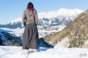
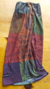 One problem you may encounter is thigh chafing when it gets hot. I solved this problem by taking a Summer Buff, sewing a little pocket around the top to push through a band of elastic, and wearing it on one of my thighs.