Hey from Etna (mile 1606)

The hike is going great. The last hundred mile section has been particularly beautiful and has insisted on me taking more breaks to relax and take it all in….or maybe I’m just getting tired.

There are many small fires ahead and I’m hoping there won’t be any trail closures.

The weather has been great; so far only one hour of rain the entire trip.

The reason I came to Etna is that I had new (badly needed) shoes sent here, but I didn’t realize that the road that you need to hitch in on is a very desolate one. Lucky for me a Christian camp bus just pulled up and unloaded 110 Christian campers on to the PCT and I rode the empty bus back into Etna. The bus driver said that he drove another 110 up to the Trinity Lakes area too.

Last night, as I was hiking, I heard noise, like people banging pots and pans together. I kept hiking and ran into a bunch of cows with bells on. I kept hiking up the switchbacks, it was after 9pm, the view was dramatic and there was a wide enough spot on the trail to lie down on so I unfurled my z-rest and camped for the night with the cow bells banging away. After awhile I didn’t even notice it.

I have seen many bears lately and many bear prints and scat on the trail.

The weather is great, the views are tremendous and there are very few bugs; all is well.

Hey from Mammoth Lakes (mile 906)

Arrived here a couple of days ago. I have been doing really great but started to get tired and slow about 100 miles ago, so I took a couple days off to try to get strong again.

The Sierras have been wonderful, but there has been more snow on the passes then when I hiked in 2001; I’m glad I’m carrying an ice ax. There has been a lot less mosquitoes though.

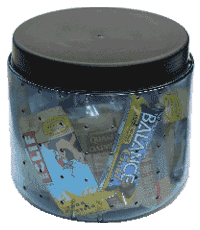
I made it through from Kennedy Meadows, 200 miles, to here with a small Bear Vault 350. I packed it full of calorie dense food like cheese, nuts, and power bars. Beware of the Twisted bars they sell at Kennedy Meadows; they contain a gag inducing combination of cod, chocolate, and pretzels.

My Chacos broke but I have gotten a new pair in town. My pack is about ready to go so I have arranged to send it in for repair and have ordered a Mountainsmith CDT to replace it.

Well it’s time to leave town and get back out on the trail. Hopefully I will be more spunky then I have been.

Hey from Cajon Pass (mile 342)

The trail is great! I think I should do this every summer, it makes me so happy to be here.

The weather has been great but I usually find some shade and take a long nap during the hotest times and hike early in the morning and late into the cool night. 

Water has not been a problem; the regular water sources are all flowing. 

 I lay out under the stars most nights to sleep.   Some nights, I find a hiker to join me in good conversation and lots of laughs. 

The desert is blooming with sweet smelling flowers. 

Yesterday, a woman at a road crossing gave me a root beer float. 

I have been trying hard not to get sucked into the towns, but the wonderful Best Western at Cajon Pass has sucked me in for a night of hot baths, iced feet, tv and a big bed.   

I always feel at home on the PCT.  It’s 2700 miles of great views, fun people and a beautifully built trail that a person can just hike, hike, hike.

I take every break right on the trail and often long naps yet only once have I had to move aside to let a person pass.  The world is lucky to have such a fine unpopulated trail. 

Hey from Julian (mile 78)

I arrived in Campo, Monday, on the evening bus, and started my hike.  About 11pm, as I was happily hiking along, an aircraft flew over me and turned it’s spotlight on me.  I waved.

The trail is beautiful and I’m very happy to be here.  Despite the drought, everything is green and the desert is blooming. 

The weather is great and I have been able to sleep under the stars every night without any bug problems. 

My feet are doing fine.  The two pair of shoes idea is working out great.  I hike mostly in Chacos but when my feet get tired I switch into running shoes and give them a break.

I hitched into Julian this morning, and plan on hanging out here until evening, then start hiking the San Felipe hills tonight.

Not many hikers out here, but some.  The guy at the Mt Lagna store said that he had thrown the hiker box away because he thought that all the hikers had gone through already.

Why did it take me so long to get back here? 


Goodbye little cabin

stay safe little cabin

I left my cabin Friday and headed to Portland. Besides going in to the little nearby town, it’s the first time I went anywhere in about 7 months. That’s a long time for me and I was happy to be going.

I’m staying at my son’s place. He lives on the tenth floor of a downtown apartment building. It’s a big change but it has a surprisingly tranquil feel to it. Having the use of a bathtub has been a nice treat.

Tomorrow morning I fly to San Diego and if all goes well, I should make it on the trail by evening.

No Trespassing signs

Just because someone nails up a no trespassing sign, it doesn’t necessarily mean that you can’t legally go there. For one thing, they may not even own the land. Often federal and state land is leased to people. Often these people begin to see the land as their own. These leases are really cheap, for instance to lease 640 acres may only cost a thousand dollars a year, but it doesn’t mean that they get to keep hikers out. I have been told by a guy who leases state land in Washington that it doesn’t give him the right to keep hikers off of it… it only gives him the right to run his cows on it and he can also restrict vehicles from coming on to the leased land.

Another thing to check is the how the land is taxed. Most of the time people who own large tracks of land have their land put it open space or forestry. This is so they pay very little taxes on their property. My neighbors chose to go with forestry because they said to go with open space would mean that anyone could come on their land. Also, even if you don’t have the right to come on private land you may have the right to use private roads that go through private land.

Resupply schedule for the Sierras–how to get through the Sierras with a 4-day bear canister.

The section through the Sierras is supposed to be rife with hungry bears. For this reason, there are lots of rules about food storage . In 2001, there were lots of rules too, but most thru-hikers ignored them and instead lived by their own rules which were: 1.Don’t cook where you camp 2.Don’t camp in established campsites, and 3. Sleep with your food. I didn’t see any bears in the Sierras that year, although I did see lots of bear poo.

Apparently the bears are more plentiful and aggressive this year and so there is a lot of persistent and emotional scuttlebutt flying around saying that you must absolutely have a bear canister. This is no small problem for people. Since many people carry 10 days, or more, worth of food through the Sierras because to resupply atBearikade Independence means hiking eighteen off trail miles.

The bear canisters are heavy. The lightest ones are made by Bearikade. They weigh 1lb 15oz(878 grams) for the 6 day model and 2lbs 5oz(1048 grams) for the 9 day model but BearVaultthey cost 250.00 and 275.00 dollars. They do have a rental program, but that isn’t cheap either.

The other one is Bear Vault. Bearvaults weighs 2lbs 1 oz(935 grams)for the 4 day model and 2lbs 9 oz(1162 grams) for the 7 day model and cost between 60 and 80 dollars. They have discontinued their rental program but they will sell you a 7 day Bear Vault canister for 65 dollars and ship it free to Kennedy Meadows, Echo Lake or Tuolumne Meadows.    Bear Vault purchase program for PCT hikers.

If I decide to go with the four day model, here is how I could do it without putting in a bunch of off trail miles and backtracking to resupply:

  • Leave Kennedy Meadows with 2 days worth of food in bear canister (mile 702.8)
  • Hike down Trail Pass(744.8) to Horseshoe Meadows campground and hitch hike out to resupply at Lone Pine. Get 6 days of food–4 days in the canister, 2 days in food bag.
  • From Horseshoe Campground take Cotton wood pass(749.6) back up to the PCT–this way there is no backtracking.
  • The first night, camp either at Wallace creek(770.4), (774.3), or Tyndall Creek(775) and use the bear boxes there, to store food in.
  • The next night camp at Rae Lakes(794.8) and use the bear box there. (Actually, by the end of this day, I would only have four days of food left so I could camp anywhere)
  • Hike the next 4 days using my bear canister.
  • Resupply Vermilion Valley Resort(877.2)–get 1.5 days of food
  • Resupply Reds Meadow (906.6)or Mammoth Lakes.– get 1.5 days of food
  • Resupply Tuolumne Meadows (941.6) get 3 days of food
  • Resupply Sonora Pass(1018.3)Either at North Kennedy Meadows or Bridgeport. If I go to Bridgeport, I think I could send the food canister and ice ax home. Get 3.5 days worth of food.
  • Mail bear canister home or back to rental place from Echo Lake(1094.5).

Update: I made it the whole 200 miles from Kennedy Meadows to Reds Meadow with a Bear Vault 350. I was able to pack 20,000 calories into it. I also met a guy carrying a map entitled, “Sierra Nevada Wilderness food storage requirements” using that map he was able to legally make it through the Sierras without carrying a bear canister.

Related Post: Figuring out how much food to bring on a hike

Still waiting……

This is getting painful–sitting here waiting for the day I get on the trail, while reading journals of everyone who is already out there. I’m going with a late start to avoid the crowds and because I don’t want to hit the Sierras too early. It’s not really late but it seems like it because everyone else is so early.

Even though I have lots of thing to do, like clean my cabin, go to the dump, and wash my sleeping bag, I just laid on my couch all day and thought about all the things I still need to do.

Someday, I hope I will be so together that I will just wake up one morning, pickup my pack, walk out the door, and go on a long hike without obsessing over the details or making a to do list.

My GPS

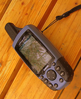
cabin2-149.jpgI bought the Garmin60c GPS to hike the CDT(Continental Divide Trail), after being told by a past thru-hiker that I would spend days lost if I didn’t carry a mapping GPS. The difference between a mapping GPS and regular GPS is that you can load it full of topo maps and then see where you are on the map. I wouldn’t have wanted to be out there without it.

It comes with a non deletable world map with all the major roads shown. Then you can add what maps you want, to it, from either a topo cd or you can go more urban and go with city maps. The topo maps show all water sources including wells. They show the mountains, contour lines, elevations, trails, roads and public institutions such as schools and fire houses. I have never had the city maps but I think they tell you about services in the cites like restaurants and stores. I don’t know if you can put both topos and city maps together. The map CD’s don’t come with the GPS and are an additional expense.

I was able to put all the topo maps for the entire CDT, plus about a fifty mile radius around the trail in it and still had room to spare. Right now, I have the topos for the entire state of Washington and most of Oregon it it. You can easily add markers on the unit and then push the goto button and it will navigate you there, either on roads or as the crow flies, which ever you choose. You can zoom in and out for more or less detail.

Garmin claims a 30 hour battery life. I used lithium batteries and got much longer then that. It was so efficient that I often hiked with it on all day . There is a model that has a compass that doesn’t have as long a battery life, but I think you can turn off the compass. This model has a compass but it doesn’t work unless you are moving.

I haven’t had any problems with it from getting it wet. I hike with it in the rain and strap it to the top of my kayak when I go out for a paddle.

It also tells you lots of other information like elevation, moving speed, timed stopped, etc.

I now have a little case for it. When I was on the CDT I didn’t have a case so I just taped some clear packing tape on the screen to protect it from getting scratched, which worked great, is light, and cheap.

It comes with a little strap and a clip. On the clip, you push a button and the unit comes unclipped from the clip. I loop the GPS through my backpack strap with the strap and then clip it my backpack using the clip. That way if the one of them should fail the other will hold it on.

It weighs 6.75 ounces(192 grams) with lithium batteries, 8.05 ounces(228 grams) if you add the case and clip.

After a month of constant use, the zoom button quit working. I sent it back to Garmin and they replaced the unit.

As is the way of electronics, now Garmin makes one that gets better signal in trees and canyons and has removable storage: the Garmin 60cx. It also looks like Garmin started making my model in a gray scale version, the Garmin 60, that will do everything mine does except without color and is considerably less than what I paid.

I’m not bringing it on the PCT, but when I hike the CDT I’ll definitely bring it. Since on the CDT the trail is often just not there.

One day on the CDT, on a hill, with the wind blowing about 35 miles an hour, I got out all my navigational aids: Jonathan Ley’s maps, Jim Wolf’s guide book, the National Forest Service map and my GPS with a past hiker’s way points in it, and tried to figure out which way to go. I knew that I wasn’t following the “official” CDT but until that moment, I didn’t realize that Jonthin Ley’s route, the guide book and my way points were all following different routes…and at that moment, I wasn’t on any of them.

I saw on my GPS, a place ten miles away that was in my guidebook so I just pointed my GPS towards where I wanted to go and took off hiking. As I set out on my own route, walking over the grassy hills, I thought, “I am happier, now, than I have ever been in my whole life.”
Build a shelter and they will come.

The shelters on the Appalachian Trail often host the most unlikely campers. One guy I saw in a shelter, carried a duffel bag full of cotton clothes, a folding chair, and a cell phone from which he made and received many phone calls. Someone else who camped with the same guy said he woke up in the middle of the night screaming her name. That would be freaky.

Another thru-hiker, I talked to, said he was at a shelter, alone, when another person showed up. They talked for a bit, then the guy stepped out of the shelter and started screaming as loud as he could, “Help!…Help!… Help!” Then he turned to the surprised thru-hiker and said with a smile, “No one can hear us here.” The thru-hiker packed up and moved on.

Serious requests only

When my son was three, we lived in a small cottage on the Oregon coast. One day while we where at the post office, we saw a big cardboard cut out of Santa Claus standing next to a mailbox that had written on it, “Santa Claus, North Pole”. We decided to write a letter to Santa. He told me what to say and I wrote it. Then we walked to the post office and put it in the red mailbox that the cardboard Santa was standing next to.

In the letter he asked for a flashlight and a rabbit cup for Christmas. We were gone at Christmas.  When we came back there was a package on the door step. Inside was a flashlight, a rabbit cup and a box of chocolates. The box of chocolates had a note on it that said “For my folks.”

The only thing I can figure out, is the mailbox wasn’t for just any kid to pretend to mail letters to Santa, but for serious requests only.

The coal miners on the Appalachian Trail.

On the Appalachian Trail I met two coal miners in their 50’s who spent their vacations, hiking a section of the trail.  Starting at the begining in Springer, they were working their way through the whole trail.  They were lots of fun; always laughing at what ever was happening. In the short time they were on the trail, they made  lots of friends. Every year, they said, that they would go back for trail days and meet up with all the folks they had met the previous years.

It made me sad to think of them leaving the trail and spending the rest of their summer in the dark mine.

Logistics

I’m pretty much ready to head out to hike the PCT(Pacific Crest Trail), but I won’t be leaving for well over a week.

I’m going to just buy my food along the way. I’m not at all picky and like the challenge and freedom of resupplying at little stores.

The last time I hiked the PCT, I bought all my food before hand and put it in 28 different boxes and paid someone to mail them to me. What a lot of work.

At first, half of the stuff from my mail drops was going into the hiker boxes because I didn’t need that much food in the begining. Then, after my appetite kicked in, half of my food ended up in the hiker boxes because I didn’t like it anymore.

It got pretty common for me to walk into town, find the post office not open, resupply with what ever I could find in town and just forget about the box. Even at Timberline Lodge where people say you can’t resupply from, I didn’t want to wait around for my box, so I just bought some stuff out of the vending machines and hiked on.

At the end of my hike I had a bunch of boxes returned to me and waiting for me at home.

On the Florida trail I had a drift box that was supposed to follow me up the trail. It had all my maps and fuel and stuff but it got lost and I didn’t get it until I got back.

On the AT I just bought along the way and only used Wingfoot’s book for navigation. I didn’t go into one post office the whole trip.

I don’t want to carry all the maps and guide books for the whole PCT so I have made up a drift box that I will keep mailing to myself, 500-700 miles ahead of me. In it I have supplements, pain relievers, socks, ice ax, water treatment, lithium batteries, guide books, maps, data sheets, etc. I really hope the post office doesn’t lose it.

For a bear canister, I can’t decide between the Bear Vault 350(2lbs 1oz) or the Bearikade weekender model(1lb 15 oz). I will decide some time up the trail. Probably order it from Agua Dulce, and have it shipped to Kennedy Meadows. I think most people are carrying the Bear Vault 450(2 lbs 9 oz) but I think it’s too heavy.

For fuel, I’m going to use what canisters I can find in the hiker boxes and stores along the way. I will start the trip without fuel, because you can’t bring it on the plane. I’m not really that into instant mashed potatoes and ramen anyway. Though, hot beverages are one of my favorite things, but, “the path is easy for those without preferences.”

For shoes I plan to hike mostly in Chacos sandals but I’m bringing along a pair of running shoes too. I really don’t want to but I know the PCT is very hard on feet and I want to have the option of giving my feet a change, when they get tired. My feet were my weakest link, the first time I hiked the PCT, and I’m hoping for happy feet this time.

I have said I was bringing the running shoes before, but when it came time to leave, I just couldn’t bear to carry the extra weight and ended up leaving them at home.