- All my stuff for my hike is here. Now, I have to clean my cabin. Then I’m out of here. #
- Entering numbers that I may need into my new phone–gear sellers, trail conditions, people, etc. #
- Eating miso soup with Brags liquid amino, seasoned gourmet rice vinegar, and a whole head of garlic in it. #
- My windows are washed. My floor is vacuumed. Still to do: go to dump, get a haircut, mail boxes. #
- If you put Brag’s liquid aminos and seasoned rice vinegar in your miso soup, you may get really thirsty. #
- Yesterday was the first warm day. I slept with all the windows open. The ponderosa pine forest smells so nice this morning. #
- It’s early, I’m online but I should get busy finishing my chores. If I keep moving, all my prep chores will be done today. #
- My cabin is cold with all the windows open. Too cold to want to stay out of my bag for long. Time to build one last fire. #
- Okay, the fire is built, the oatmeal is eaten yet here I am still not doing my chores. #
- I’m sleepy. Time for a nap before chores. #
- I didn’t want to leave gas in the chainsaw so I went out, in my robe, and cut wood till it ran out of gas. Luckily it didn’t take long. #
- I cut some kindling so that when I come home, in the fall, it will be there for me to build a fire. Okay… back to my chores. #
- At my sister’s. She is not here. I am using her bathtub, watching her tv, and eating the shaved ice her refrigerator makes. #
- Now that I have cell reception, let me see if I can send a message. #
Month: May 2008
Goodbye little cabin!

I have packed up, cleaned up, drained my generator and chainsaw of gas, and picked a bouquet of sage and sunflowers for the cabin guarding spirits. This show is moving to the big city.
Trail Twitter
Trail Twitter

Through no fault of my own, I am acquiring a free blackberry phone, via my son’s account. And since hiking doesn’t pay and I have had more than enough Internet in my life lately, I don’t think I’ll be spending the 30 bucks to turn the data plan on. Rather, I’m thinking of doing a Trail Twitter with the free unlimited text messaging feature. This phone also comes with a built in spell checker.
Tom of “Two-Heeled drive” is big on this Twitter thing; that’s where I heard about it.
Might be stupid, might not be. Word press will post a blog entry once a day from them. The direct link to my twitter is http://twitter.com/sistercrow
Escape from the rat king
“The Herd” should be at least 400 miles along by the time I hit the trail. Unless they come back to hike a section that they skipped because it was icy or on fire, I shouldn’t have to deal with them for a month, maybe more.
The Herd is a teeming rat king of 50-75 hikers that hike within a day or two of each other. Last year, I would meet people, who were hiking in the opposite direction, that would tell me about them. They would shake their heads and laugh and say they weren’t like hikers. There was one report that they had drank up an entire town’s beer supply.
For a long time, I would just hear about them; I was meeting few hikers. The reports started getting closer and closer to me. Then, one early morning, as I was walking on the aqua-duct, all these hikers started rising off the desert floor and joining me. It was like something out of “Night of the Living Dead.” I knew if I couldn’t get out of that mire of hikers my trail would be done. Through fear spawned tenacity and great effort, I quickly escaped.
Forest discovery.
I found a national forest that I can walk to from my cabin. So, now my training hikes are a 19.5 mile loop that includes lunch and a nap in the forest. I carry all my gear, a bunch of water and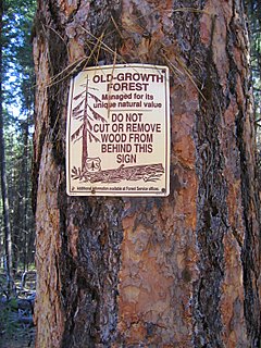 some random cans of food for added weight. I was carrying a big 55 lb load that included two packs, firewood, a bear canister filled with canned food, and some water jugs. But I like having my gear with me, because I can imagine just continuing on forever and carrying a 55lb pack isn’t that much fun.
I believe the Pacific Crest Trail goes through this forest. Even though I see the Cascades looming in the distance every day on my walks, the trail seems like a long way away.
There are these signs up that say it is an old growth forest. It’s not a very impressive forest, I have much bigger trees on my property, which I think might be their point–that if you don’t thin, the trees stay small and crowded. I think it may be fire suppression that causes the crowded forest but maybe it’s the way it’s supposed to look.
One day, on my hike, I passed by a man’s house. He said, “You look like a traveler. Can I offer you some water.” I had to tell him I was only a pretend traveler, right now, and that thanks, but my load held lots of water. He looked confused. I’m excited to begin my travels for real and stop being a pretend traveler.
The .05¢ cup of coffee
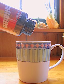 This is my newest supplement for the trail— ProLab Caffeine
It seems a little sleazy to take caffeine in pill form instead of getting it from coffee and colas, but I don’t know why it does. I pay extra for energy bars that have caffeine. Often when I buy a coke it’s the caffeine I’m after. I got to thinking why not just buy a bottle of caffeine. It’s cheap —5.00 dollars for 100 pills of performance enhancing goodness.
The scariest place on the Pacific Crest Trail(PCT)
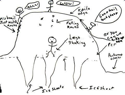
Up in Washington in the Goat Rocks Wilderness is where I think the scariest place on the PCT is; it’s this huge steep slide area. When I first went across it in September of 2001, there wasn’t much snow and it was late in the day so what snow there was, was soft. It looks like the whole mountain above you is just about ready to come falling down on you. I would look up and see rocks starting to fall. After I crossed it, I thought, “This is totally unsafe, there is no way this is the PCT. Somewhere I must of taken a wrong turn.” So back across the huge slide area, back across Packwood Glacier, and back down the trail trying to find where I went wrong. After I figured out that the slide area was the PCT, I went back across it again.
The next time I crossed it, in August of 2006, I got there first thing in the morning and there were 3 solid ice shoots to cross on the big slide area. I walked across the first one fine, reminding myself of Jardine’s wisdom, ” You don’t fall until your mind falls.” But after taking a few steps, out into the second ice shoot, my legs started shaking. I thought, “This is bad.” Carefully stepping backwards a few steps, I made it off the ice shoot; I crossed the one that I had just crossed and walked back to Packwood Glacier.
There is another trail that goes up and over the top of this area. It’s about a 500-to-600 foot elevation gain but the trail is good going up. Once on top you are walking a 2 foot wide crest that is very dramatic. I thought, “This is the way to go. This is a much grander route.” But coming back down it on the other side, the trail just disappeared and was nothing but these little round marbles of rocks to slid down on. After getting back down to the PCT, I felt like I needed a drink.
The next time I crossed it, in August of 2007, I knew to wait until the sun had soften the snow and since it was the section of trail my son had joined me on it was logistically easy to have him bring the ice ax and take it back with him when we were done. There was only one snow shoot to cross last year. I carried the ice ax and made good steps for my son to follow in. You should probably always kick steps as if someone you care about is following you.
This year has been a big year for snow in Southern Washington, I may carry my ice ax through here again. I will also make sure I’m not crossing it first thing in the morning.
The Goat Rock Wilderness in Washington in August is the most beautiful place on PCT. Often you walk on the crest and the crest is just three feet wide. There are wild flowers and green mountainsides. I saw at least 60 mountain goats last year through there. It will make you happy. If you can only hike one section of the PCT, that would be the one I would recommend. Don’t go if it’s raining.
Logistics: My son and I drove his car up to White Pass Cracker Barrel where they let us park it for the week for free. Then we drove back to Portland in another car and his girlfriend drove us to the trail head by Stabler’s Store–about 35 trail miles north of Cascade Locks. Then we hiked together to White Pass.
When we got to White Pass, I said that I was done hiking and I wanted to go home to Portland with him. He said, “Fine. Why don’t you go in the store and pick us up some Cokes for the road.” I went in to get us some Cokes and he drove off. I kept hiking to Canada. Thanks, James.
I have the whole PCT in my GPS
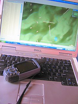 This is my GPS; it’s the Garmin 60c. It weighs 6.7 ounces(190 grams) with lithium batteries. I bought it in 2004 for hiking the Continental Divide Trail. Since I have it, I thought it might be fun to bring it on the Pacific Crest Trail(PCT) with me.
I was able to get all the topos for the entire trail plus quite a bit of the area around the trail on it. To figure out what maps I needed, I marked all the towns along the way on the program “mapsource” and than just clicked on all the maps that they were in and the ones that connected them.
At first I was just kicking around the idea and seeing if all the topos would fit but then I started thinking that it might be useful and fun to bring it along.
Last year as I was hiking through the Sierras, I thought, “You know, if a bunch of new snow fell, I would have a really hard time navigating through here.” I don’t want to be a person who follows footprints.
Another area where it might come in handy, is if there is a fire, I would be able to see the ways around it. The guide book maps are great when you are on the trail but if you, say, asked me where I was in relation to something outside of the guide book maps, I probably couldn’t tell you. It’s nice to be able to get a big picture of things.
It could also give me more freedom and confidence to try different routes. Often I just stick to the PCT because it’s easy to follow and my maps cut off other routes.
I’ll just see how it goes. If I decide that it’s not useful, I can put it in my resupply/bounce box and ship it along.
Note: The DVD with all the topos on it is called: Garmin MapSource Topo U.S. 2008
Update: I have switched to the Garmin 60CSx
Related Posts:
My GPS
Keeping your GPS screen from getting scratched.
My big independent resupply box
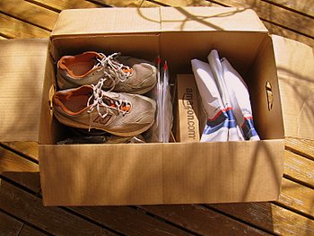 This is my resupply box. It took me a trip into town and all day with a tape measurer to find it. My ice ax just fits in it. Even if I had Photoshop, I don’t think I would put a big sunburst coming off of it, but I guess it will do. In the picture it looks pretty good. After I took the picture, I wrapped more cardboard around it so the ice ax won’t punch a hole in it. I used tape and wood glue. Now it looks like a big mess that is going to be caught up in the automated machine at the post office.
I have made big signs with my name and brightly colored dots on them to decorate each side. I did that so that at the post office I can say, “It’s the big box with my name and big colored dots on it” and they can quickly find it.
Once I used a plastic bin to mail my maps and stuff I needed for a trail. I think the post office thought it looked suspicious because it disappeared and I didn’t get it until my trip was done.
My dream box is a plastic or waxed corrugated box with a lid that fits all the way over it so that it’s doubled. I would make it a couple inches too big so that my ice ax could be seated in foam to keep it from gouging my box. When I wasn’t off hiking, the box could be used to store my gear in.
Maybe that is too big of a dream for this year but I did find a a place on the internet called custommadeboxes.com that makes boxes like this. I wrote away for an estimate.
Update: custommadeboxes.com got back to me with a quote. The price for 1 of a double cover box in a coroplast material with the dimensions 26 x 12 x 14 is $37.58 plus shipping. That sounds like a nice box but I think I will use the box I have for this year and continue to think about my options for my permanent resupply/gear box.
Best yogurt ever.
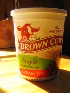 This is the best yogurt– Brown Cow maple. The cream is on top so you need to stir it. I discovered it 3 years ago at the food coop. It says it’s made in California so it’s probably sold all over.
WARNING: If you stick a spoon it it, you will eat it all.